
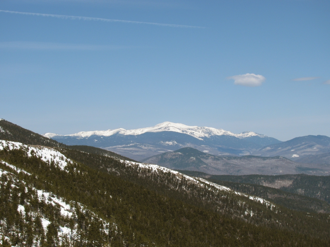
Iron Mountain, as seen from the summit of South Moat, in the foreground of Mount Washington!
Iron Mountain has always been an intriguing mountain to me ever since the first time I noticed it on my trail map. I would even go as far as saying it is my favorite mountain. The mountain and its trails seem to stand alone, secluded from the vast trail network that New Hampshire houses in its backcountry. One can reach the trailhead by traveling up a secluded, dirt road, a few miles out on Iron Mountain Road, off from Route 16 in Jackson. The road climbs a few hundred feet in elevation in these couple miles and dumps you off at an old pasture and farmhouse, with spectacular views to the Presidentials. The trailhead itself is known to be one of the best views you can obtain on this hike, being picturesque in both the foreground and background landscapes. As one would imagine on such a secluded trail, the Iron Mountain Trailhead is simply marked with a homemade wooden sign that simply says “TRAIL”.
Iron Mountain Trailhead Sign, Taken September of 2009
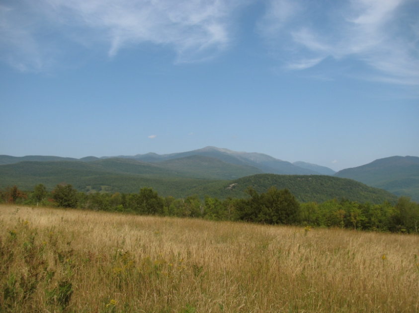
View up to Mount Washington from the pasture at the trailhead, phenomenal views
Wildcats from the first viewpoint just below the summit
This mountain is very rich with history, although, there is not a whole lot of published information on it. In the 1800’s, as the name alludes, the southeastern slopes were used for iron mining. Prior to these mining operations, the mountain was actually called Baldface, I’m assuming for the large and bare rock exposed on its southern slopes! The only publication I can find that narrows down the timeline for these mines was from the 1922 edition of the AMC White Mountain Guide, which says on page 241, “They (the mines) were worked about 1872.” It also goes onto explain that there was once a hiking trail that ran from Jericho Road (which runs on the south side of the mountain) up to the mines by way of an old carriage path that was actually used to gain access to the mines when in operation. It gives a good account of the mine layout, explaining a 60 foot tunnel and an old mine shaft filled with water. When I made my way down to the mine area by way of the published spur path on current maps, I think I found the large shaft filled with water and found dumps of ore deposit on the slopes. I did not find the tunnel to speak of. However, I can say that the spur path we ascended was very difficult to follow and even more difficult to backtrack, as it was marked with small cairns, made up of only two or three small rocks. 100 years later, there is no published trail that leads up to the iron mines from Jericho Road. In fact, even a USGS map from 1942, only 20 years later, shows no sign of a trail connecting the two points.
Piles of rocks I found next to a shaft with water in it
I found some rocks with drill marks in them down in the mine area
Some of the best views on Iron Mountain can be seen from the southeastern slopes on what is called the South Cliffs. This wide open ledge has great views all the way to Sandwich Range. It is an easy hike down from the summit and is close to the junction with the current Iron Mine Spur path. I recall sitting on these ledges with Jill, no one else in sight, and feeling that it was extremely peaceful. We enjoyed the views and really fell in love with the spot. My understanding is, the only place that you can really get a good view of the South Cliffs (from another location) is Mount Pickering and Mountain Stanton. These cliffs are a great location to go if you feel like spending time in the White Mountains by yourself.
View as you walk onto the South Cliffs
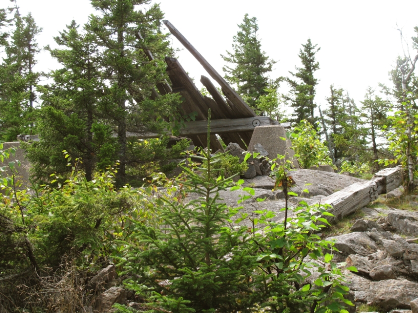
The summit is another historical location. Apparently, many years ago in the 1800’s, you could stand on this summit and have fine views toward the village of Jackson, NH. Today, the summit has a lot of tree growth on it and views are limited or nonexistent. The way to get up there today is by way of the Iron Mountain Trail from the field and farmhouse that I described in the beginning of this post. It is a steep, somewhat eroded path, but there are some really fine viewpoints on the way up toward Mount Washington and the Wildcats. On the summit, are remnants of the
old fire tower that once stood tall. It was a wooden tower, thirty feet in height and was in operation from 1939 to 1948, and then sold in 1949. Some wooden ties, rusted hardware, a broken down platform and some concrete leg supports are still on the summit. I’ve even found a USGS Reference Mark on the summit, but have never found the Benchmark that goes with it.
Remnants of the fire tower that once stood
More debris of the tower
USGS Reference Mark on the summit
Another trail that was used by hikers to make their way up to the summit was from Route 16. It was a trail that was blazed by W.A. Meserve of Jackson, NH in 1905. I’m not sure what the name of this path was or if it ever had a published name. The trail left from a pasture behind the old Iron Mountain House, which was built in 1861 and closed in the late 1980’s. It ultimately burned down in the year 2000 and the
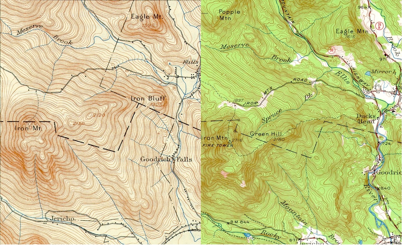
Red Fox Pub was erected in its place. This trail meandered under the now wooded cliffs of Duck’s Head. Here’s another interesting fact. Duck’s Head used to be known as Iron Bluff, a sub-peak of Iron Mountain. It is labeled Iron Bluff on the 1896 USGS map, but labeled Duck’s Head on the 1946 USGS map. Okay, back to the trail. It split near the top of Duck’s Head, where you could go to the, at the time, open ledges over Jackson or head west to the Iron Mountain summit. This route also took you over another sub-peak known as Green Hill. This trail no longer exists. I’m not sure if it is still bushwhacked from time-to-time or not.
Left Map: 1896 USGS Map, showing the peak near Route 16 as Iron Bluff
Left Map: 1942 USGS Map, showing the peak near Route 16 as Duck’s Head
Click the image to make it larger
Current published trails on a modern AMC map
Iron Mountain was also the home of a ski area, Iron Mountain Slopes. It is considered one of the lost ski areas in New Hampshire and I believe it was located just south of the Fire Fox Pub on route 16, but I can’t say for sure. There is a website,
New England Lost Ski Areas Project, that has a lot of information on this historical slope. It looks like one of the organization’s members bushwhacked the old slopes a while back and found many of the ski area’s equipment still on the mountain side. There are pictures of the old rope tow equipment as well as the summit return building just about falling in. The summit return building still has all the old wheels for the ropes, an old stove and even the motor that ran the tow. The ski slopes have completely grown in with tree growth and are nearly impossible to make out with the comparison pictures on that site. I can imagine it is really cool to stumble across this historical equipment when walking through the woods.
Before and after image of the Iron Mountain Ski Slope: Taken from NELSAP.org
Summit Return Building, still up on the slopes: Taken from NELSAP.org
Rope Tow structure, with trees growing around it.Taken from NELSAP.org
Iron Mountain will always be one of my favorite mountains. I think, back in its heyday, Iron Mountain was a very significant landmark to the village of Jackson. Even the small bridge on Route 16 over Ellis River, just north of junction with Green Hill Road (once called Iron Mountain Road) was known as Iron Mountain Bridge.The mountain was well-known and could be accessed from many different paths, but now only one secluded trail leads to its summit. It once had sub peaks named after it, which have now been renamed, forgetting about the origins. It has been mined and skied, but the evidence of this is buried in the woods and is difficult to find. It has had a fire tower planted on its summit and dismantled shortly after. I believe the summit has even been used for surveying or map making at one time since I found the USGS Reference Mark up there. I feel as though Iron Mountain has lived out its life and is now a forgotten peak. As I have said in many of my posts, I hope to retire to Jackson, NH or possibly even move up there sooner. If I do get up there one day, I will certainly hike this mountain often; find all the old paths that were once blazed and all the historical remnants left behind of better days on Iron Mountain!
This blog is a New Hampshire Day Hiker’s Blog that may be of interest to hikers in the New England region. Enjoy! http://livefreeandhikenh.blogspot.com/
Read more at Live Free and Hike
Source:
Please Help Support BeforeitsNews by trying our Natural Health Products below!
Order by Phone at 888-809-8385 or online at https://mitocopper.com M - F 9am to 5pm EST
Order by Phone at 866-388-7003 or online at https://www.herbanomic.com M - F 9am to 5pm EST
Order by Phone at 866-388-7003 or online at https://www.herbanomics.com M - F 9am to 5pm EST
Humic & Fulvic Trace Minerals Complex - Nature's most important supplement! Vivid Dreams again!
HNEX HydroNano EXtracellular Water - Improve immune system health and reduce inflammation.
Ultimate Clinical Potency Curcumin - Natural pain relief, reduce inflammation and so much more.
MitoCopper - Bioavailable Copper destroys pathogens and gives you more energy. (See Blood Video)
Oxy Powder - Natural Colon Cleanser! Cleans out toxic buildup with oxygen!
Nascent Iodine - Promotes detoxification, mental focus and thyroid health.
Smart Meter Cover - Reduces Smart Meter radiation by 96%! (See Video).


