
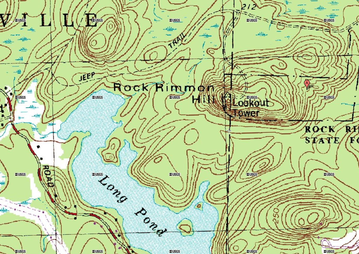
I’m on vacation this week and had some free time on Tuesday. I decided to stay in the seacoast region as I didn’t feel like a long drive up north. I headed over to the Danville-Kingston area to explore Rock Rimmon Hill which is located in New Hampshire’s Rock Rimmon State Forest. The hill is 345 feet at the summit and is a pretty steep drop off or cliff on the southern side. It can be accessed from both Kingston and Danville depending on where you are coming from.
Based on my findings, there is really minimal information out there on the short hike to this summit. The AMC Southern New Hampshire Trail Guide (2nd Ed.) has an outdated explanation on the trailhead description…and I’ve heard through the grapevine that they have removed it from AMC’s 3rd Edition all together, although, I cannot confirm this. A fellow VFTTer gave me pretty detailed directions on how to access this hill from the Kingston side, but also warned me that where you leave your vehicle is pretty susceptible to break-ins, so that way was out for me. I found on another blog a way to get to the trail network from Danville, so I opted to go that way!
I parked on the corner of where Emerald Drive and Opal Drive meet. At this corner, there is an old Jeep road that heads into the woods…you can’t miss it. Just as an aside, the USGS maps do not show this corner, as (I assume) the area was not developed at the time they were mapped out. It looks like Emerald Drive may have actually been an extension of the old Jeep road at one time.
Old Jeep Road at the corner of Emerald and Opal Drive
Since there is no good trail maps or trail descriptions of the area, I was pretty much winging how to get to the top. I knew I was in the right area, and if whatever way I chose to go ascended, I figured I must be going the right way. After heading down the Jeep road for about 50 feet, I hung a right. This trail was also wide enough to be an old Jeep road. I passed through some boulders blocking the road and soon saw a small swamp to left. The trail curved to the left, right after the swamp area and started to climb gently. I noticed while climbing, there was a foot trail that crossed the trail (or Jeep road) I was on. I figured I better stay in the direction I was headed and would explore this trail on my way back down.
Gate on the old Jeep road to the summit
Small icicles forming on some rocks on the banking of the trail
Further up, I found an old gate that looked like it hadn’t been closed in years. I also found some recent deer rubs on some small trees off to the side. There was a lot of standing water that had frozen over higher up on the trail and I need to bushwhack to the side of the trail for much of the way. Soon, the trail turned to rocky slabs and the view opened up. The view to the south was very nice. Long Pond was easy to make out and I’m sure if it had been a clear day, I could have seen quite a ways further. I noticed right away that the area had been quite abused. There was broken glass and spray paint markings all over the ledge. There were also quite a few empty beer cans. I hate seeing such a nice place littered so badly.
Fresh buck rub on a small tree on the trail
Walking onto the summit of Rock Rimmon Hill
View to the south, with Long Pond in the center through the trees
More views
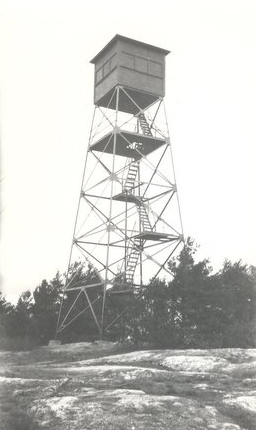
After taking in the views, I headed over to the western part of the ledges where four fire tower foundation pillars were still securely in place. The foundation pillars still had the steel flange brackets that secured the legs of the old fire tower. The fire tower that stood here was in service from 1928 to 1982 and was removed in 1989. Below is an old photo of this tower standing on Rock Rimmon Hill and it was taken from
FireLookOut.org.
Old Fire Tower Location on the summit
Fire Tower Flange, still mounted to pillars
What I think is an old guide wire eyelet for the fire tower
On the west side of the fire tower location, I found what appeared to be a foot trail leading off the hill. It was steep and somewhat easy to make out for a bit. I soon came to a small rock cave where the trail appeared to end. I could not figure out for the life of me where it continued after exploring for a bit. I took a quick rest at the rock cave and heard an odd sound. It sounded like small rain drops on the fallen leaves just before a shower hits. But, there were no drops coming from the sky. I looked down and saw millions of snow fleas starting to migrate for the winter. It reminded me of the many winters I used to see these same types of snow fleas in my backwoods at my home in South Hampton while growing up. I observed the snow fleas for a bit and then headed back up to the summit.
Small rock cave on the west side of the hill
Look closely…Snow fleas!!!
Back at the top, I headed north and back down the old Jeep road I ascended from. Around the old gate that I had passed on the way up, I noticed a foot trail, blazed in orange, to the left. I decided to take this path to see where it went. I continued down the hill, through a beech wood forest, and came to an area in the woods that looked awful. It had been ridiculously blazed with blue, orange and pink paint and flags. Now, I understand the need for trail blazes and boundary markers, but this was ridiculous. It completely took away the natural look of a beautiful forest. The foot path soon crossed the Jeep road, at the spot where I had noticed a trail crossing during my ascent.
A very ugly portion of the woods, blazes and flags everywhere…all different colors
I finally came to the swamp that I had passed on the way up, but this time, it was on my left. It was a very nice maple swamp, frozen over with white ice. It had a small foot bridge which was a bit altered and disfigured due to previous winter’s ice movement. I really thought this spot was peaceful, but I’m really not sure why. Again, I think this area reminded me of the maple swamps behind my folks house, where I spent a lot of time, cutting wood and walking through the forest with my father. I snapped a few shots and continued on.
Nice looking maple swamp!
Bridge through the swamp
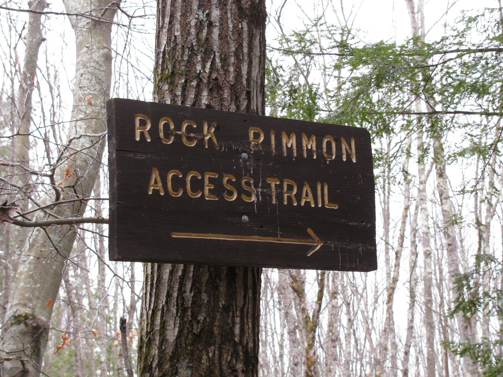
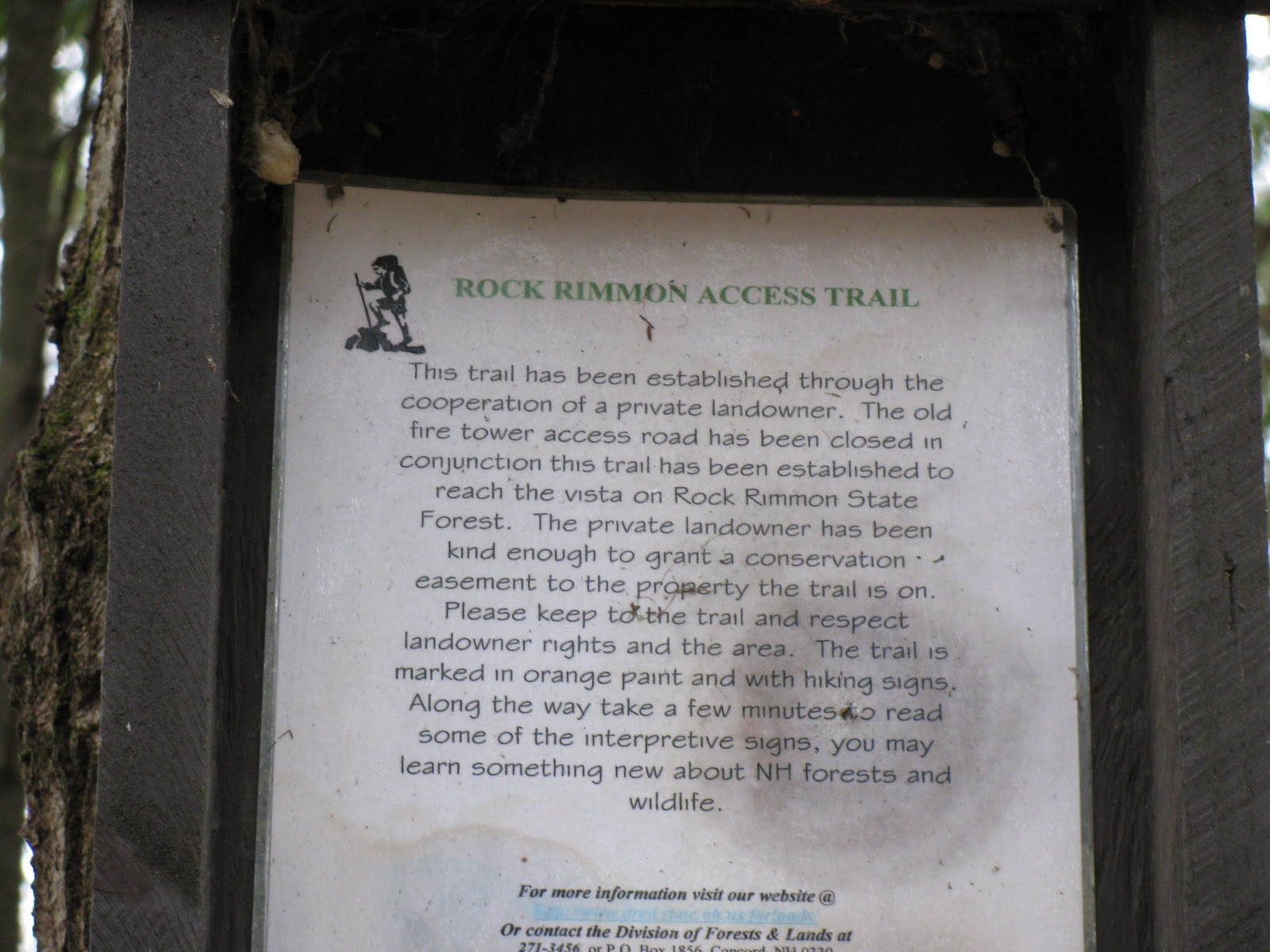
Finally, the trail dumped me off at the original old Jeep road, a bit further up than where I turned in at the beginning of my trek. I noticed that there was a trailhead sign which said Rock Rimmon Access Trail. I assume this is the “official” trailhead for Rock Rimmon Hill. At this point, I noticed some nice, old stone walls off to the side. I explored them a bit, snapped some shots and headed back out to where my truck was parked.
Rock Rimmon Access Trail Sign
Information regarding the trail and landowners
Some nice stone walls
All in all, I’m guessing I only covered a mile or two, but I had a fun time not really “knowing” where I was going. I felt a bit blind, but it made the exploration more enjoyable that way. I still had more of the afternoon ahead of me, so I decided to head to the Lamprey River Floodplain to check out some beaver activity. I’ll save that trip report for my next posting!
This blog is a New Hampshire Day Hiker’s Blog that may be of interest to hikers in the New England region. Enjoy! http://livefreeandhikenh.blogspot.com/
Read more at Live Free and Hike
Source:
Please Help Support BeforeitsNews by trying our Natural Health Products below!
Order by Phone at 888-809-8385 or online at https://mitocopper.com M - F 9am to 5pm EST
Order by Phone at 866-388-7003 or online at https://www.herbanomic.com M - F 9am to 5pm EST
Order by Phone at 866-388-7003 or online at https://www.herbanomics.com M - F 9am to 5pm EST
Humic & Fulvic Trace Minerals Complex - Nature's most important supplement! Vivid Dreams again!
HNEX HydroNano EXtracellular Water - Improve immune system health and reduce inflammation.
Ultimate Clinical Potency Curcumin - Natural pain relief, reduce inflammation and so much more.
MitoCopper - Bioavailable Copper destroys pathogens and gives you more energy. (See Blood Video)
Oxy Powder - Natural Colon Cleanser! Cleans out toxic buildup with oxygen!
Nascent Iodine - Promotes detoxification, mental focus and thyroid health.
Smart Meter Cover - Reduces Smart Meter radiation by 96%! (See Video).


