
Pawtuckaway Mountains and an Old Friend!


mine that I don’t see that often. My buddy, Daigle, is a civil engineer
and has been working on location in various cities across the country,
managing major construction projects for new bridges. He was home for
the week between Christmas and New Year’s and was nice enough to set
aside some time for hiking with me.
was to hit the Whites, but when the westward winds blew in on
Wednesday, so did all the cold weather. Many of the trail condition
postings mentioned that crampons should be used on the higher ledges of
most peaks. Since neither of us had crampons…or were experienced
winter hikers, we thought it may be wise to stick around the seacoast
region where there is still no snow!
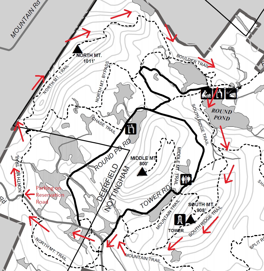
never been to Pawtuckaway State Park, I figured that would be a good
place to spend the day. I mapped out a route that started on Reservation
Road at the North Mountain Trailhead, traversed over North Mountain,
down the Boulder Trail and then traversed South Mountain via the South
Ridge Trail. We’d finish the complete loop by continuing on the South
Ridge Trail and hiking back up Reservation Road to where we originally
parked. I estimated the loop to be between 7 or 8 miles, but I still
haven’t had time to take the guide and actually figure the mileage out
yet.
The trek into the foot of North Mountain is easy and flat and goes by
quickly. At the foot of North Mountain, the trail climbs the
southwestern slope pretty steeply. It wasn’t long before I was huffing
and puffing, and realized how out of shape I was. I’m sure the loads of
chocolates and pie that I consumed during the holiday season didn’t help
either! Due to the steep pitch, it wasn’t long before the trail
flattened out. We found a nice rock perch facing the east and stopped
for some coffee while we tried to identify landmarks in the distance.
Daigle was great at this. He quickly picked out Portsmouth and Great Bay
through the binoculars.
consuming our warm beverages, we continued over North Mountain, which is
a very long ridge. We finally came to the high point, which is marked
with a cairn. I explored this area a bit and it wasn’t long before I
spotted NGS Reference Mark. I was surprised to find this because I had
been up there before and never noticed it. After researching these
markers, I knew there must be at least one or two more. Low and behold, I
found two more. Using the triangulation of them, they were pointing
directly to the cairn. So I wonder if the Benchmark was actually buried
under the cairn? I am kicking myself for not digging into it to see if
it was there. If it was, I wonder why someone would have burried it?
Anyway, it’s bugging me enough that I want to get back up there and see
if I can unearth the thing. If an NGS Benchmark exists, the cairn should
really be reassembled next to it!
the mountain, we came to the large billboard like communications
reflector that is painted green and faces to the north. I’m going to be
honest, I have no idea if this reflector is still used today or what it
is (was) used for. This thing is pretty large and is really an eyesore. I
also have no clue how long it has been out there.
the north slope of the mountain was pretty easy and we quickly passed
the Devil’s Den to our right, which is a very large cave, and Dead Pond
on our left. The trail is pretty flat as we continued down the Boulder
Trail and we passed a portion of Round Pond on the right and some large
cliff features on our left. The trail got pretty confusing at this
point, because the trail junctions on the map are covered by boating,
scenic outlook and fishing markers! Daigle was able to guide us in the
correct direction and we were headed up the South Ridge Trail.
must say, the trails in Pawtuckaway are either flat or very steep.
There doesn’t seem to be any moderate grades up to these mountains! We
made it to the top of South Mountain very quickly and were the only ones
on the summit. We climbed the fire tower and the wind from the west
pelted us pretty hard. Again, Daigle pointed out all the
landmarks…Northwood, Portsmouth, the Uncanoonucs. I think we even
spotted Mount Washington’s white cap way off in the distance, but I
can’t be sure. We snapped a few shots and headed back down to find a
windless, sunny spot for lunch. When we were done eating, we got moving
pretty quickly as the temperature was dropping with the wind. The trek
back to the truck was quick and easy. We made the loop in just 3-1/2
hours which I thought was pretty good time.
definitely a fun hike. Spending time in the woods is always one of my
favorite pastimes, but catching up with an old friend definitely tops
that. Daigle is heading down to North Carolina for a new assignment now.
Hopefully we can catch up again on another hike when heads back home
later this year.
This blog is a New Hampshire Day Hiker’s Blog that may be of interest to hikers in the New England region. Enjoy! http://livefreeandhikenh.blogspot.com/
Read more at Live Free and Hike
Source:
Anyone can join.
Anyone can contribute.
Anyone can become informed about their world.
"United We Stand" Click Here To Create Your Personal Citizen Journalist Account Today, Be Sure To Invite Your Friends.
Please Help Support BeforeitsNews by trying our Natural Health Products below!
Order by Phone at 888-809-8385 or online at https://mitocopper.com M - F 9am to 5pm EST
Order by Phone at 866-388-7003 or online at https://www.herbanomic.com M - F 9am to 5pm EST
Order by Phone at 866-388-7003 or online at https://www.herbanomics.com M - F 9am to 5pm EST
Humic & Fulvic Trace Minerals Complex - Nature's most important supplement! Vivid Dreams again!
HNEX HydroNano EXtracellular Water - Improve immune system health and reduce inflammation.
Ultimate Clinical Potency Curcumin - Natural pain relief, reduce inflammation and so much more.
MitoCopper - Bioavailable Copper destroys pathogens and gives you more energy. (See Blood Video)
Oxy Powder - Natural Colon Cleanser! Cleans out toxic buildup with oxygen!
Nascent Iodine - Promotes detoxification, mental focus and thyroid health.
Smart Meter Cover - Reduces Smart Meter radiation by 96%! (See Video).


| Online: | |
| Visits: | 1,602,525,088 |
| Stories: | 8,147,311 |
Whistler Blowers, Insiders
