
Far Side Of The Moon As Never Seen Before: LRO Camera Team Releases High Resolution Global Topographic Map Of Moon


This new topographic map, from Arizona State University in Tempe, shows the surface shape and features over nearly the entire moon with a pixel scale close to 100 meters (328 feet). A single measure of elevation (one pixel) is about the size of two football fields placed side-by-side.
LROC WAC color shaded relief of the lunar farside. (Credit: NASA’s Goddard Space Flight Center/DLR/ASU)
Although the moon is our closest neighbor, knowledge of its morphology is still limited. Due to instrumental limitations of previous missions, a global map of the moon’s topography at high resolution has not existed until now. With the LRO Wide Angle Camera and the Lunar Orbiter Laser Altimeter (LOLA) instrument, scientists can now accurately portray the shape of the entire moon at high resolution.
“Our new topographic view of the moon provides the dataset that lunar scientists have waited for since the Apollo era,” says Mark Robinson, Principal Investigator of the Lunar Reconnaissance Orbiter Camera (LROC) from Arizona State University in Tempe. “We can now determine slopes of all major geologic terrains on the moon at 100 meter scale. Determine how the crust has deformed, better understand impact crater mechanics, investigate the nature of volcanic features, and better plan future robotic and human missions to the moon.”
Called the Global Lunar DTM 100 m topographic model (GLD100), this map was created based on data acquired by LRO’s WAC, which is part of the LROC imaging system. The LROC imaging system consists of two Narrow Angle Cameras (NACs) to provide high-resolution images, and the WAC to provide 100-meter resolution images in seven color bands over a 57-kilometer (35-mile) swath.
The WAC is a relatively small instrument, easily fitting into the palm of one’s hand; however, despite its diminutive size it maps nearly the entire moon every month. Each month the moon’s lighting has changed so the WAC is continuously building up a record of how different rocks reflect light under different conditions, and adding to the LROC library of stereo observations.
The LROC (WAC) has a pixel scale of about 75 meters (246 feet), and at the average altitude of 50 km (31 miles) a WAC image swath is 70 km (43 miles) wide across the ground-track. Since the equatorial distance between orbits is about 30 km (18 miles) there is complete overlap all the way around the moon in one month. The orbit-to-orbit WAC overlap provides a strong stereo effect. Using digital photogrammetric techniques, a terrain model can be computed from the stereo overlap.
The near-global topographic map was constructed from 69,000 WAC stereo models and covers the latitude range 79°S to 79°N, 98.2% of the entire lunar surface. Due to persistent shadows near the poles it is not possible to create a complete stereo based map at the highest latitudes. However, another instrument onboard LRO called LOLA excels at mapping topography at the poles. Since LOLA ranges to the surface with its own lasers, and the LRO orbits converge at the poles, a very high resolution topographic model is possible, and can be used to fill in the WAC “hole at the pole.” The WAC topography was produced by LROC team members at the German Aerospace Center.
“Collecting the data and creating the new topographic map was a huge collaborative effort between the LRO project, the LOLA team, the LROC team at ASU and in Germany at the DLR,” says Robinson. “I could not be more pleased with the quality of the map – it’s phenomenal! The richness of detail should inspire lunar geologists around the world for years to come.”
Shaded relief images can be created from the GLD100 by illuminating the “surface” (in this case the shape model) from a given Sun direction and elevation above the horizon. To convey an absolute sense of height the resulting grayscale pixels are painted with colors that represent the altitude. Visualizations like these allow scientists to view the surface from very different perspectives, providing a powerful tool for interpreting the geologic processes that have shaped the moon.
The LRO spacecraft is managed by NASA’s Goddard Space Flight Center in Greenbelt, Md., for NASA’s Science Mission Directorate in Washington.
Future versions
The current model incorporates the first year of stereo imaging; there is another year of data that can be added to the solution. These additional stereo images will not only improve the sharpness (resolution) of the model but also fill in very small gaps that exist in the current map. Also the LROC team has made small improvements to the camera distortion model and the LOLA team has improved our knowledge of the spacecraft position over time. These next generation steps will further improve the accuracy of the next version of the LROC GLD100 topographic model of the moon.
Global topography
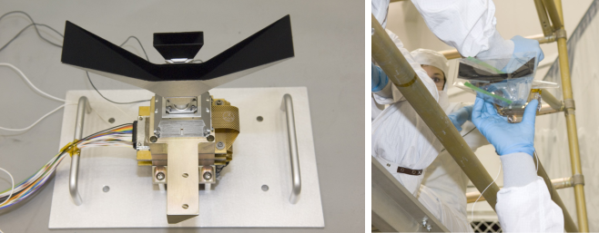
Global topography — a boon to lunar scientists and explorers around the world! Today the LROC team releases Version 1 of the Wide Angle Camera (WAC) topographic map of the Moon. This amazing map shows you the ups and downs over nearly the entire Moon, at a scale of 100 meters across the surface, and 20 meters or better vertically. Despite the diminutive size of the WAC (it fits in the palm of one’s hand), it images nearly the entire Moon every month. Every month? Yes! Redundant data? No! Each month the Moon’s lighting changes, so the WAC methodically builds up a record of how different rocks reflect light under different conditions, and adds to the LROC library of stereo observations. The WAC really is the little camera that could! It was built by Malin Space Science Systems (MSSS) in San Diego CA, and is very similar to another MSSS camera (MARCI) that is now in orbit around Mars.
Left: LROC Wide Angle Camera attached to a test setup shortly before mounting on the spacecraft. Right: WAC being handed up to engineers for integration with LRO
(photos M. Robinson).
The WAC has a pixel scale of about 75 meters, and with an average altitude of 50 km, a WAC image swath is 70 km wide across the ground-track. Because the equatorial distance between orbits is about 30 km, there is nearly complete orbit-to-orbit stereo overlap all the way around the Moon, every month. Using digital photogrammetric techniques, a terrain model was computed from this stereo overlap. The new topographic model was constructed from 69,000 WAC stereo models. Due to persistent shadows near the poles it is not possible to create a complete WAC stereo map at the very highest latitudes. Fortunately, the LRO Lunar Orbiter Laser Altimeter (LOLA) excels at characterizing the topography of the poles. Since the LRO orbits converge at the poles and LOLA ranges to the surface with its own lasers, LOLA provides a very high resolution topographic model of the poles. This LOLA map can fill in the WAC “hole at the pole”.
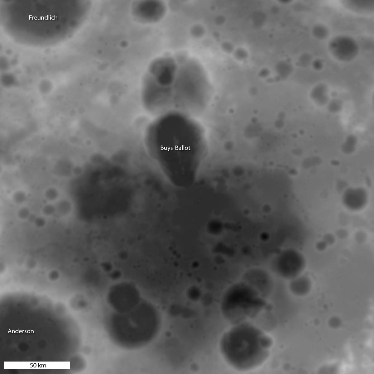
Detail from WAC topography model, shades of gray represent elevation. Darker values are lower terrain, while brighter values are higher points. Image center is near 19.1°N, 175.3°E
(NASA/GSFC/DLR/Arizona State University).
How is a digital topographic map created from stereo images? The WAC stereo images were compared one against another by pattern-matching a moving box of pixels until the best fit was found between two images with different viewing angles. Best fit pixel positions are combined with the LRO orbit position and the WAC viewing angles to define two 3D rays (lines of sight). The intersection point of these rays defines the location and the elevation of the point on the surface. Since the correlation box is bigger than 100 meters, surface details at the 100-meter scale are not fully resolved in a single stereo pair. However, each 100 meter square has an average of 26 stereo points within it (for a planet-wide total of 100 billion points), which helps to sharpen the elevation estimate. The resolution, in a formal sense, is probably close to 300 meters, and the accuracy of the elevations is estimated to be about 10 to 20 meters. This new map is called the Global Lunar DTM 100 m topographic model, or “GLD100”, and covers 79°S to 79°N latitudes, 98.2% of the entire lunar surface. The WAC topography was produced by LROC team members at the German Aerospace Center (DLR).
Color shaded relief detail corresponding to same area shown in figure above
(NASA/GSFC/DLR/Arizona State University).
Shaded relief images can be created from the GLD100 by illuminating the surface from a given Sun direction and elevation above the horizon, and to convey an absolute sense of height the resulting grayscale pixels are painted with colors that represent the altitude. Visualizations like these allow scientists to view the surface from very different perspectives, providing a powerful tool for interpreting the geologic processes that have shaped the Moon.
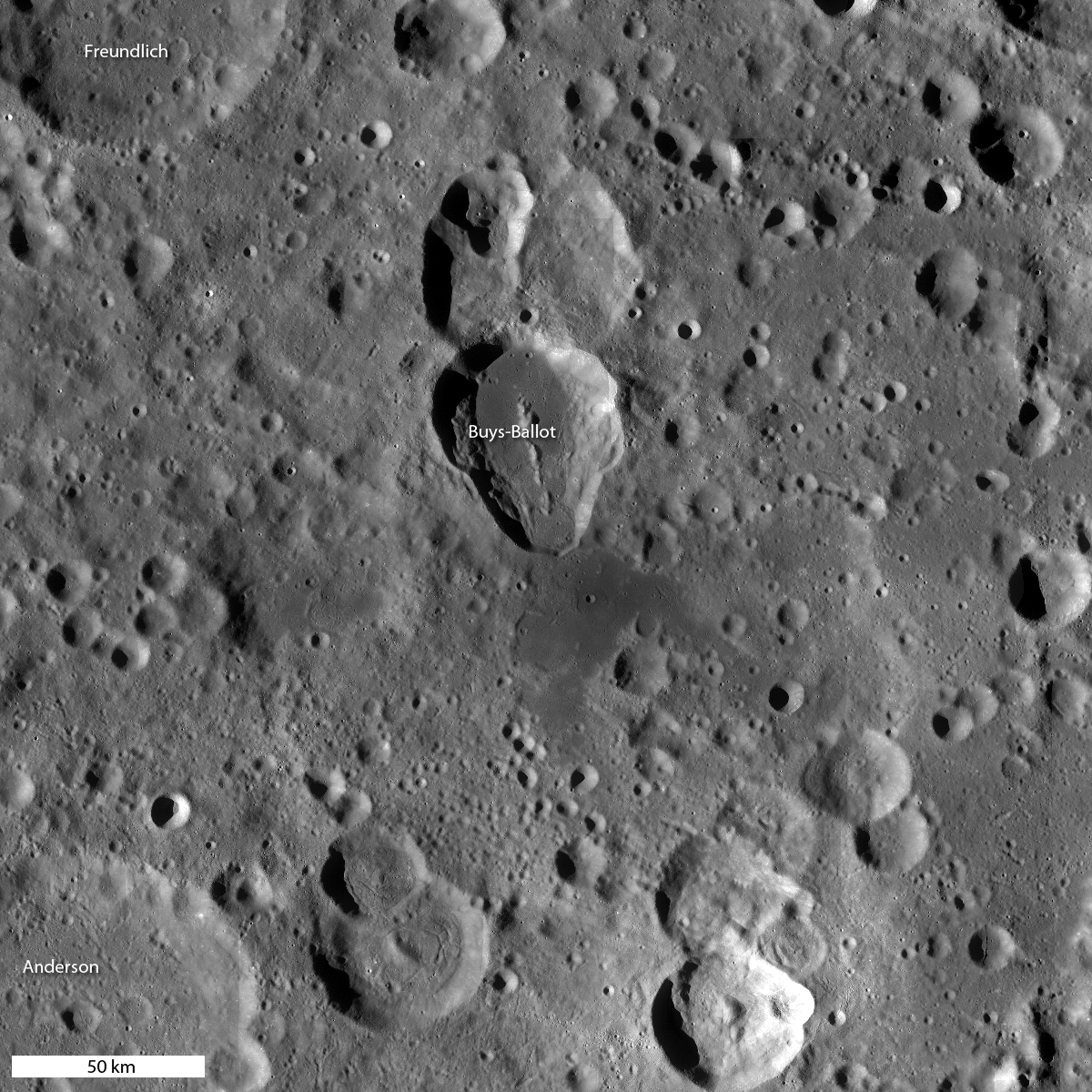
WAC mosaic corresponding to same area shown above
(NASA/GSFC/DLR/Arizona State University).
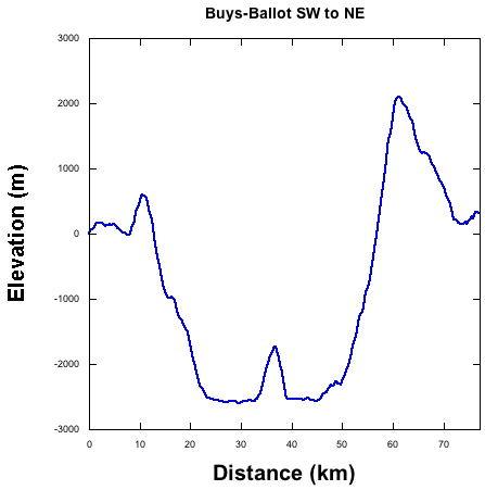
The large irregularly shaped Buys-Ballot crater, seen in the three images above, is about 47 km by 62 km. The WAC topography shows the flat floor to lie some 3100 meters below the western rim and 4600 m below the eastern rim. The central peak rises about 800 m above the floor. For comparison the width and depth of this crater are larger than those of the Grand Canyon, AZ.
Topographic profile (highly exaggerated) across Buys-Ballot crater, note the flat floor
(NASA/GSFC/DLR/Arizona State University).
Why is the floor of the crater so flat? The WAC mosaic holds an important clue — note how dark the floor is. On the Moon, dark (low albedo) material is typically basalt, which is dark because it is relatively rich in iron (mafic minerals). On the Moon, basalts are erupted as very hot lavas, making them very fluid, thus they tend to spread out and flood local topographic lows. From the topography and WAC image data, one can make a confident interpretation that the floor of this unusual crater is most likely flooded with basalt. But why such a small eruption? Most flood basalts on the nearside cover vast expanses of lunar terrain, but why not on the farside? Another mystery for future lunar explorers to unravel!
The area shown here is only a tiny portion of the Moon: see if you can find Buys-Ballot in the full resolution hemispheric view.
What improvements can be made over this first release of the LROC WAC GLD100? The current model incorporates the first year of stereo imaging, and there is another year of data that can be added to the solution. These additional stereo images will not only improve the sharpness (resolution) of the model but also fill in very small gaps that exist in the current map. The LROC team has made small improvements to the camera distortion model, and the LOLA team has improved our knowledge of the spacecraft position over time. These next generation steps will further improve the accuracy of Version 2 of the LROC GLD100 topographic model of the Moon.
Explore the new LROC GLD100!
Direct links to color shaded relief visualizations:
Orthographic projection centered at 0° longitude and 0° latitude.
Orthographic projection centered at 60° longitude and 0° latitude.
Orthographic projection centered at 120° longitude and 0° latitude.
Orthographic projection centered at 180° longitude and 0° latitude.
Orthographic projection centered at 240° longitude and 0° latitude.
Orthographic projection centered at 300° longitude and 0° latitude.
Orthographic projection centerd at 0° longitude and 90° latitude.
Orthographic projection centered at 0° longitude and -90° latitude.
NOTE: OS X users may have a problem opening the large TIFF files directly from the browser. Please right click and choose “Save As”.
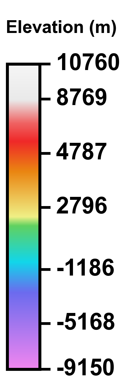
Color scale legend for LROC Color Shaded Relief
(NASA/ GSFC/ DLR/ Arizona State University).
Contacts and sources:
NASA
Arizona State University
Mark Robinson
Read more at Nano Patents and Innovations
Source:
Anyone can join.
Anyone can contribute.
Anyone can become informed about their world.
"United We Stand" Click Here To Create Your Personal Citizen Journalist Account Today, Be Sure To Invite Your Friends.
Humic & Fulvic Liquid Trace Mineral Complex
HerbAnomic’s Humic and Fulvic Liquid Trace Mineral Complex is a revolutionary New Humic and Fulvic Acid Complex designed to support your body at the cellular level. Our product has been thoroughly tested by an ISO/IEC Certified Lab for toxins and Heavy metals as well as for trace mineral content. We KNOW we have NO lead, arsenic, mercury, aluminum etc. in our Formula. This Humic & Fulvic Liquid Trace Mineral complex has high trace levels of naturally occurring Humic and Fulvic Acids as well as high trace levels of Zinc, Iron, Magnesium, Molybdenum, Potassium and more. There is a wide range of up to 70 trace minerals which occur naturally in our Complex at varying levels. We Choose to list the 8 substances which occur in higher trace levels on our supplement panel. We don’t claim a high number of minerals as other Humic and Fulvic Supplements do and leave you to guess which elements you’ll be getting. Order Your Humic Fulvic for Your Family by Clicking on this Link , or the Banner Below.

Our Formula is an exceptional value compared to other Humic Fulvic Minerals because...
It’s OXYGENATED
It Always Tests at 9.5+ pH
Preservative and Chemical Free
Allergen Free
Comes From a Pure, Unpolluted, Organic Source
Is an Excellent Source for Trace Minerals
Is From Whole, Prehisoric Plant Based Origin Material With Ionic Minerals and Constituents
Highly Conductive/Full of Extra Electrons
Is a Full Spectrum Complex
Our Humic and Fulvic Liquid Trace Mineral Complex has Minerals, Amino Acids, Poly Electrolytes, Phytochemicals, Polyphenols, Bioflavonoids and Trace Vitamins included with the Humic and Fulvic Acid. Our Source material is high in these constituents, where other manufacturers use inferior materials.
Try Our Humic and Fulvic Liquid Trace Mineral Complex today. Order Yours Today by Following This Link.


| Online: | |
| Visits: | 1,617,712,386 |
| Stories: | 8,192,810 |
Whistler Blowers, Insiders

agreed
that is the nearside dumbass. And I saw that pic years ago. Moron
I had seen on You Tube, that the moon had vicious little creatures and that’s why we never went back.
I also heard the tape of NASA (when only the employees at NASA were supposed to be hearing; however, there was an error and the broadcast stated that ET’s were flying by them.
I went to see Apollo 18 a few weeks ago, and saw the same thing that was stated about “why we didn’t go back to the moon.”
There were vicious little creatures there (reminded me of the Alien movies with Weaver in them.
Hahahh The airbrush boys will be very busy, won’t they
Well I have examined a picture from this set using photoshop, and their touchups are everywhere…..
photoshopping stands out like a sore thumb !!
Hmmmmmm……………no evidence of american flags and rover tracks on this side either………….
No NWO, go to You Tube — there is a video about why we didn’t go back to the moon. At the time, I kept the video but didn’t quite know what to think.
Go see Apollo 18. There is original footage…but the outcome
is that there are vicious little creatures there who “infected” our men.
See NASA airbrush at work again…and we pay these people to lie to us.
What the hell…we buy a newspaper and pay the Marxist (AP) media for lies.
We pay the salaries of the Federal Justice Dept. and they lie to us.
We pay millions to the Obama’s and they lie!
Damn…lost cause!
Quit giving them your money!
Nice. Even though its fake, nice.
I heard it was swarming with discs(UFO`s)parked everywhere on the surface and distinct structures indicating a city of some sort! Go to 2010Thecountdown who has amazing pictures of the moon.
I meant to say it is a youtube channel.
I have seen the same You Tube Video. Did you see the one (I think it was Apollo I) where the channel to be heard ONLY by NASA was mistakenly left as an open microphone to the audiences listening and watch TV — when they stated UFOs were flying all around them?
I did see that other video also of all of the building structures left in shambles (or rotting or destroyed at one time)?
Go See Apollo 18!!!!
It is so sad to see nasa keeping on talking with the same idiotocracy as the nwo with them using the still same old line of thinking that their ancient masters had instructed them in thinking that over the last lets say a few tens of thousands of years that the human race still are idiots and cannot by means reason.
Where we the ones who awaken more by the thousands each week are becoming knowledged of great deceptions we have been held under for so long. this is our greatest tool against the nwo and its pets. That we who are awake cannot be deceived we know by our inner feelings and our minds wisdom which is also staring to crack away at the shell of the nwo because they are starting to make grammar school level mistakes. Which would have been okay back thousands of years ago but not against us.
WOW! Look at all the alien bases everywhere.
No, sorry, it was Elenin again…my mistake.
Th far side of the moon as never seen before?? who is the moron who wrote this??high on pot?? more desinformation from NASA indeed!
This link is interesting http://www.youtube.com/watch?v=bCTwzm8QyRg